


Dave Catts
Current Gallery: oldtopos ( piece)
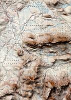
Historical U. S. Geological Survey 15-minute topographic maps that have been draped over the current terrain to add a hint of shaded relief. No collar information is included, just the image; but the effect adds a three-dimensional look to these classic maps of a time where mapping was an art of manual skill and craftsmanship, not some push-button technology. It was a time of "engravings", "copper plates", "lithography" and some real death-defying field surveying techniques.
Historical U. S. Geological Survey 15-minute topographic maps that have been draped over the current terrain to add a hint of shaded relief. No collar information is included, just the image; but the effect adds a three-dimensional look to these classic maps of a time where mapping was an art of manual skill and craftsmanship, not some push-button technology. It was a time of "engravings", "copper plates", "lithography" and some real death-defying field surveying techniques.
Gallery-quality prints · Independent artists · Décor to adore


from $ 63

from $ 63

from $ 63

from $ 63

from $ 63

from $ 63

from $ 63

from $ 63

from $ 63

from $ 63
from $ 63

from $ 63

from $ 63

from $ 63

from $ 63

from $ 63

from $ 63