


Dave Catts
Current Gallery: rockies ( piece)
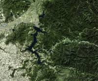
Images of the Western United States predominately ranges in the Rocky Mountains, with anomalies from the "Horst-and-Grabben" regions of Utah and Nevada, the Grand Canyon region, and the Black Hills of South Dakota: birds-eye views of familiar places, camping, hiking and fishing spots: geography, places to visit and recreate. The map titles are from a central physiographic feature and contain over-edge. All images are vertical views (planimetric) of 3D environmental models, and the image corners are specific geographic coordinates (georectified). These images are 10,000-pixels in the longest dimension; so they can accommodate the "Massive" print size at Imagekind.
Images of the Western United States predominately ranges in the Rocky Mountains, with anomalies from the "Horst-and-Grabben" regions of Utah and Nevada, the Grand Canyon region, and the Black Hills of South Dakota: birds-eye views of familiar places, camping, hiking and fishing spots: geography, places to visit and recreate. The map titles are from a central physiographic feature and contain over-edge. All images are vertical views (planimetric) of 3D environmental models, and the image corners are specific geographic coordinates (georectified). These images are 10,000-pixels in the longest dimension; so they can accommodate the "Massive" print size at Imagekind.
Gallery-quality prints · Independent artists · Décor to adore


from $ 63

from $ 63

from $ 63

from $ 63

from $ 63

from $ 63

from $ 63

from $ 63

from $ 63

from $ 63

from $ 63

from $ 63

from $ 63

from $ 63
from $ 63

from $ 63

from $ 63

from $ 63

from $ 63